Calakmul Biosphere Reserve
What is Calakmul and why is it unique?
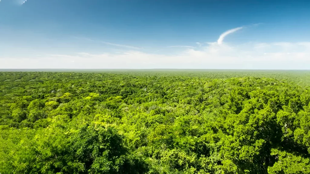
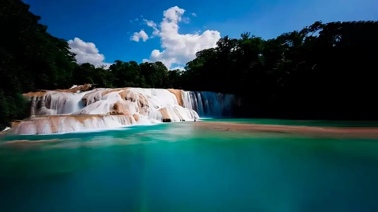
The Calakmul Biosphere Reserve is one of the largest and best-preserved blocks of continuous tropical rainforest in Mesoamerica.
Located in the municipality of Calakmul, Campeche, it forms a regional biological corridor with the Maya Biosphere Reserve in Petén (Guatemala), a key element within the biocultural landscape of the Great Mayan Jungle.
With 7,231 km² (723,185 ha) and IUCN management category VI, the Calakmul Biosphere Reserve was decreed in 1989 and today protects semi-evergreen forests, seasonal waterholes and remnants of highland rainforest that support populations of big cats and ungulates, as well as a remarkable diversity of flora and fauna.
Due to its exceptional value, the “Ancient Mayan City and Protected Tropical Forests of Calakmul, Campeche” complex was inscribed by UNESCO as a Cultural Asset in 2002 and recognized as a Mixed Asset (natural and cultural) in 2014, formally incorporating the jungle environment that makes possible the conservation of the archaeological site and its ecological processes.
This “mixed” nature positions Calakmul as a benchmark for the conservation and comprehensive management of natural and cultural heritage.
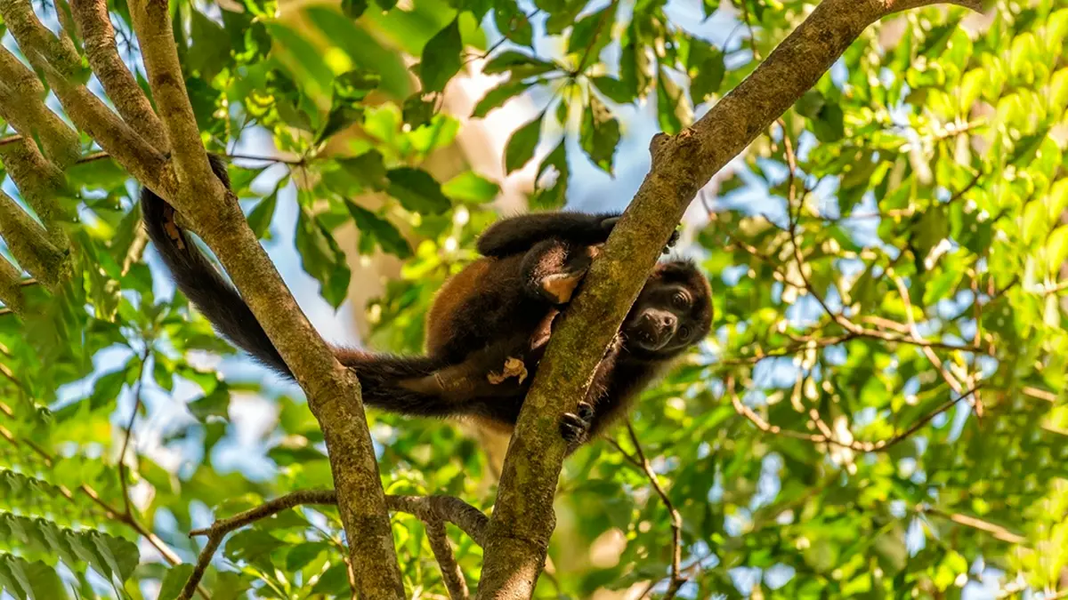
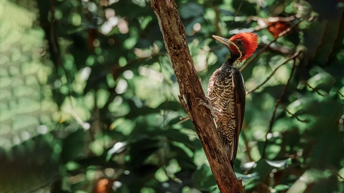
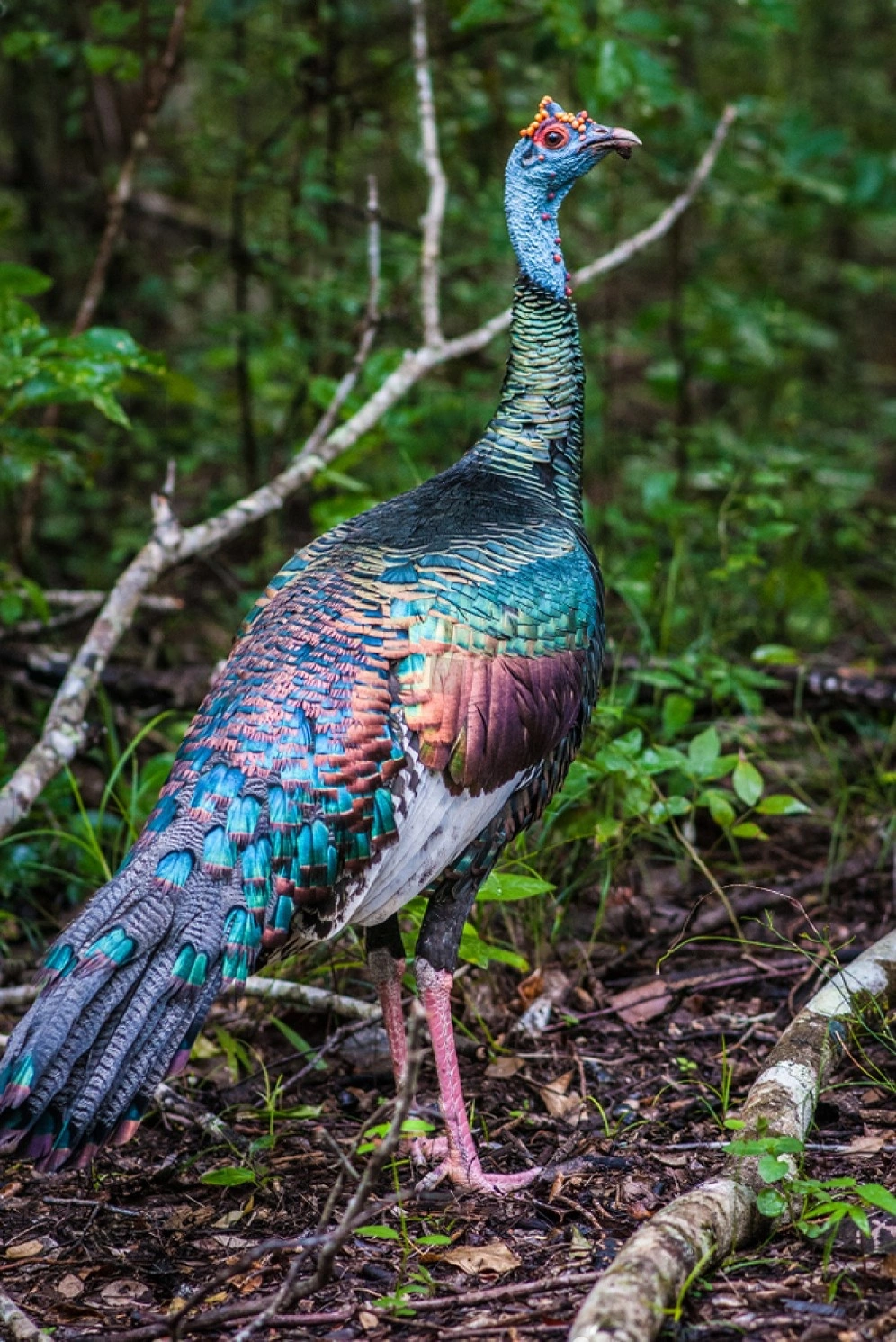
In terms of biodiversity, 86 mammal species and 358 bird species have been documented, in addition to reptiles, amphibians, and invertebrates of high conservation interest.
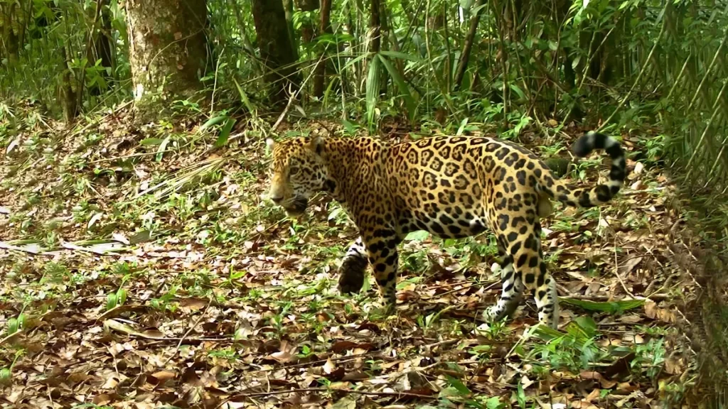
The connectivity of the Calakmul Biosphere Reserve with neighboring areas allows for the maintenance of viable populations of jaguars (Panthera onca) and other large carnivores, a distinctive feature of the Great Mayan Forest.
How to get there and get around
The most frequently used access point is the Federal Highway 186 (Chetumal–Escárcega) road corridor, which connects with Xpujil and adjacent towns, from which tours to the core of the reserve and the archaeological sites are organized.
Access via secondary roads requires providing fuel, water, and cash; in sections of the jungle, mobile coverage is limited or nonexistent.
For safety and logistical efficiency, it is recommended to coordinate transfers with local providers, either for one-day visits or for 2–3-day plans that combine wildlife observation and archaeological heritage.
Travel times vary depending on the starting point and road conditions.
For official route updates, it is recommended to consult local authorities or community visitor centers for route updates.
Responsible driving—moderate speeds, headlights on at dawn/dusk, and respect for wildlife—is essential to reduce road accidents and disturbances in the jungle.
Best season and weather
The climate is warm with small annual temperature fluctuations and rainfall around 750 mm, with marked seasonality.
During the dry season, the aguadas (waterholes)—karst depressions that store water—concentrate wildlife and facilitate responsible sightings; during the rainy season, water dynamism increases and vegetation reaches its peak.
Planning outings for early morning and late afternoon improves the likelihood of observing birds and mammals, while reducing heat stress and sun exposure.
To avoid impacts, visits should be tailored to the carrying capacity of trails and viewpoints; it is recommended to coordinate with accredited guides to interpret signs of wildlife presence without disturbance.
During months of high rainfall, travel on secondary roads may require higher-clearance vehicles and appropriate tires.
What to see inside the reserve
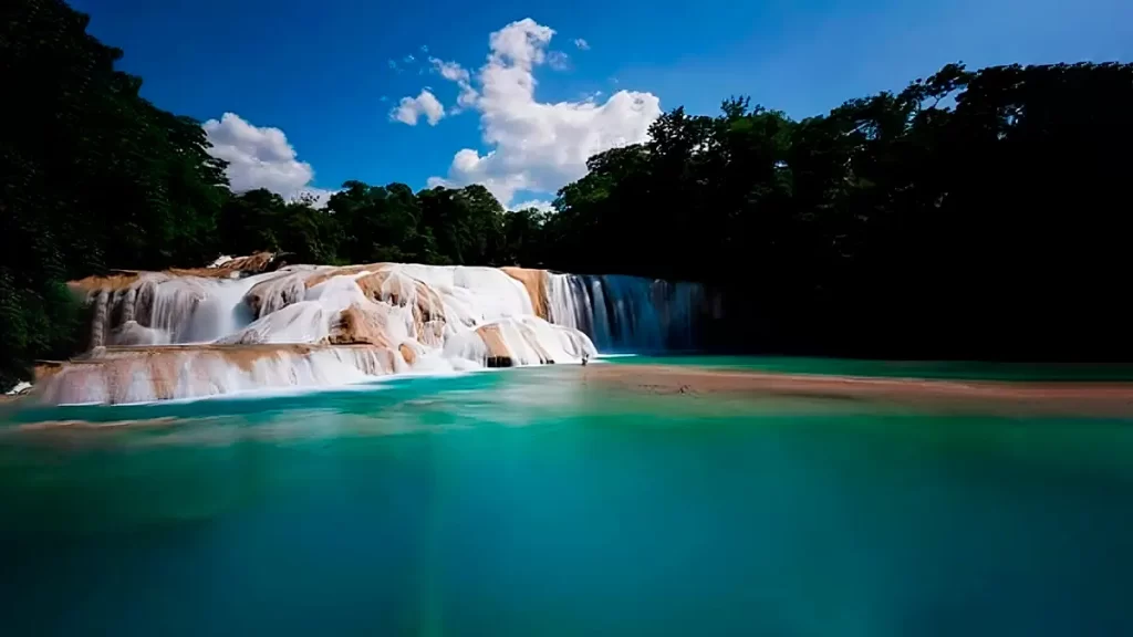
Calakmul offers a mosaic of mid- and highland forests, natural clearings, waterholes, viewpoints, and biological corridors that connect with Balam Kú and other conservation areas.
The diverse habitats support assemblages of resident and migratory birds, as well as emblematic mammals.
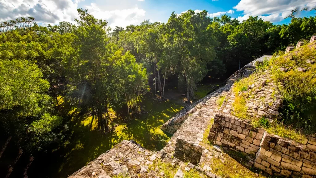
The network of archaeological sites—Calakmul, Xpujil, Becán, Chicanná, and Hormiguero, among others—allows for the integration of itineraries that alternate nature and culture, reinforcing the narrative of the UNESCO-recognized Cultural and Natural Landscape.
The interpretive trails and wildlife observation points are preferably explored with local guides, who provide information on the location of active waterholes and wildlife crossings and provide guidance on safe behavior (observation distances, silence, and no feeding).
The Calakmul Biosphere Reserve prioritizes low-impact experiences with an educational and community focus.
Archaeology in the jungle
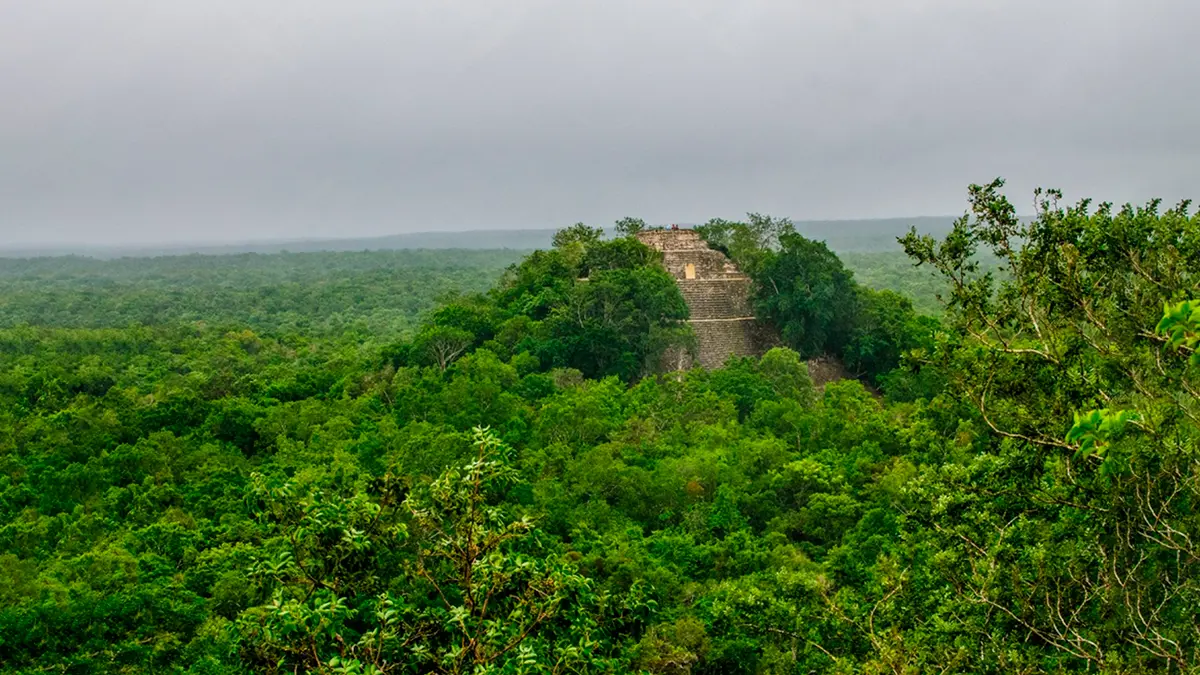
The archaeological site of Calakmul is located within the reserve, integrating monuments, stelae, and large foundations into the context of the sub-evergreen forest.
The complex is associated with other Mayan cities in the region—Becán, Chicanná, Xpujil, and Hormiguero—allowing for the design of heritage circuits with an integrated historical and environmental interpretation.
This visitation model underscores the interdependence between the conservation of built heritage and the ecological processes that sustain its integrity.
The status of a Mixed Property reinforces the need for respectful visitation protocols: capacity control, circulation along established routes, non-removal of cultural or biological material, and coordination with custodians to minimize disturbances, especially during periods of high humidity or extreme heat.
Recommended activities
The Calakmul Biosphere Reserve promotes environmental interpretation, birdwatching, hiking, and community tourism activities with a focus on the local economy.
Local operators and community centers facilitate tours to viewpoints, watering holes, and archaeological sites, as well as cultural experiences in Mayan communities.
By spending the night in ecovillages and low-density accommodations, visitors contribute to local development and reduce pressure on wildlife.
These activities align with “leave no trace” standards, prioritize small groups, and promote environmental education.
For those seeking nature photography, medium-long focal lenses, a lightweight tripod, and glare-reducing filters are recommended; in all cases, safe distances should be maintained and playback should be avoided to attract birds, given its potential impact on behavioral patterns.
Practical advice
- Equipment and preparation: Essentials include sufficient water, repellent, sun protection, hiking shoes, and a basic first-aid kit.
- Waste management: based on the principle of total return; everything that goes in, comes out.
- Road and field safety: Avoid driving at night; communicate your itineraries to accommodations or guides; carry a headlamp and a copy of identification.
- Payment methods and connectivity: ATM and POS availability may be limited; please bring cash and confirm reservations in advance.
- Local guides and operators: Hiring community services facilitates access to up-to-date information on wildlife and trails, and strengthens local capacities.
These providers adopt good observation practices, monitor distances and time spent at sensitive points, and provide guidance on environmental etiquette.
Conservation in progress
The Calakmul conservation model combines federal management of a Protected Natural Area with landscape-scale connectivity schemes.
At the social-environmental level, the Calakmul Conservation Fund (FMCN) promotes Payment for Environmental Services (PES) initiatives in strategic ejidos to maintain the habitat continuity of the jaguar and other focal species through conservation agreements and participatory monitoring.
This approach strengthens functional connectivity between forest cores and discourages high-impact land-use changes.
At the regional level, the Greater Calakmul region—as part of the Greater Maya Forest—integrates more than 1.5 million hectares of forests and adjacent PNAs, coordinating public and community efforts.
Inter-institutional and civil society coordination is essential to maintain biological corridors and manage pressures associated with population growth, subsistence hunting, and infrastructure development.
Preguntas frecuentes
Calakmul Biosphere Reserve: World Heritage Site
Calakmul is a strategic biocultural landscape in the Great Mayan Forest.
Its management requires informed visits, coordination with local providers, and adherence to low-impact guidelines.
Responsible tourism—aligned with environmental interpretation, support for community economies, and respect for carrying capacity—directly contributes to sustaining the connectivity, diversity, and ecological processes that distinguish this reserve.
Table of ecosystems
Gran Selva Maya
Calakmul Biosphere Reserve — Summary table for responsible public use
Summary Table — Calakmul Biosphere Reserve
Ecosystem ↔ Focal species ↔ Management scope ↔ Best practicesScope and guidelines
Scope: operational table for low‑impact public use. Apply CONANP guidelines, the Management Program, and the area zoning (core zones and buffer zone). This material does not replace permits nor current regulations.
| Ecosystem (CBR) | Focal species (examples) | Recommended management scope | Key best practices |
|---|---|---|---|
| Tall/medium subevergreen forest | Jaguar (Panthera onca), spider monkey (Ateles geoffroyi), howler monkey (Alouatta spp.) | Core: research/monitoring; Buffer: interpretive hiking on official trails | Groups ≤10, quiet operation, >50 m from mammals; no playback; stay on trails |
| Low subevergreen/subdeciduous forest | Ocelot (Leopardus pardalis), margay (Leopardus wiedii), white‑tailed deer (Odocoileus virginianus) | Core: preservation; Buffer: low‑impact guided routes | Walk single‑file; avoid burrows; do not geotag sensitive wildlife; zero waste |
| Low deciduous forest | Ocellated turkey (Meleagris ocellata), Yucatán amazon (Amazona xantholora) | Core: monitoring; Buffer: distance viewing at designated points | No playback; keep >100 m at roosts; use binoculars; short dwell times |
| Marshes and seasonally flooded bajos | Morelet’s crocodile (Crocodylus moreletii), herons (Ardeidae) | Core: strict preservation; Buffer: viewing from edges/platforms | Distance ≥15 m from crocodiles; no drones; no water entry |
| Aguadas and seasonal hydrology | Amphibian and waterbird assemblages; wildlife visiting waterholes | Core: no public use; Buffer: lookouts and boardwalks | No soaps/repellents in water; avoid soft shores; dwell ≤15 min per point |
| Caves and rock shelters (bats) | Insectivorous bat colonies | Core: preservation/research; Buffer: observation only at authorized sites | No flash; quiet; >100 m from colonies; no drones unless permitted |
| Archaeological settings within forest matrix (Calakmul Archaeological Zone) | Mixed bird and invertebrate assemblages; understorey flora | Guided heritage visit; integrated biocultural interpretation | Do not touch/climb structures; respect signage; no flash in restricted spaces; follow official routes |
Entry & logistics: check official notices from the ANP Directorate/CONANP and the Descubre ANP platform; mobile coverage is limited. Plan for water, cash, and fuel; avoid night driving. Permits for research/filming must be obtained from the ANP Directorate.